CONTEMPORARY NY
New York Architecture Images-New York Bridges

Roosevelt Island Bridge

architect


location

connects Roosevelt Island to Long Island City in Queens

date

1955

style

Structural Expressionism

construction

100 ft (30 m) of vertical clearance. It is 40 feet (12 m) wide, and its total length, including approaches, is 2,877 feet (877 m). The main span is 418 feet (127 m).

type

Bridge

images

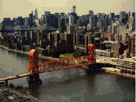
  The Roosevelt Island Bridge, crossing over the East Channel of the East River, in its closed position. Roosevelt Island is in the foreground, and the Manhattan skyline is in the background. RIGHT: The Roosevelt Island Bridge in its open position. The Con Edison plant in Long Island City, Queens is in the background. (Photos by New York City Department of Transportation.)
The Roosevelt Island Bridge is a lift bridge that connects Roosevelt Island to Long Island City in Queens. It is the sole route to the island for vehicular and foot traffic (without using public transportation). Construction of the bridge began on March 17, 1952, at a cost of $6.5 million. It opened in 1955 as the Welfare Island Bridge.

When the bridge is open it provides ships with 100 ft (30 m) of vertical clearance. It is 40 feet (12 m) wide, and its total length, including approaches, is 2,877 feet (877 m). The main span is 418 feet (127 m).
 
HISTORY OF ROOSEVELT (WELFARE) ISLAND: What is known today as Roosevelt Island was first purchased from the Algonquin Indians in 1637 by the Dutch, who promptly renamed the island "Varckens Eylandt," or "Hog Island." In the 1660's, the British reclaimed the island from the Dutch after years of dispute. The island was granted to Captain John Manning, the sheriff of New York. In 1673, Manning was sentenced to death (later commuted to life imprisonment on the island) for relinquishing New York's Fort James to the Dutch without a shot.

When Manning died in 1686, stepdaughter Mary Manningham renamed the island after her husband, Robert Blackwell. Blackwell Island remained in private hands until 1828, when the City of New York purchased it and transformed it into a setting for mental institutions, hospitals and prisons. Reflecting this setting as a repository for the down and out, the city renamed the property Welfare Island in 1921.

PROVIDING ACCESS TO THE ISLAND: Initially, access to Welfare Island had been through a series of ferries from Manhattan and Queens. In 1930, a four-cab elevator service began between the lower deck of the Queensboro (59th Street) Bridge and the island. The service, which had served 230,000 cars per year by the early 1950's, provided the only public connection to Welfare Island.

The increasing traffic needs to and from Welfare Island, as well as growing congestion on the Queensboro Bridge, prompted the New York City Department of Public Works to propose a new vertical-lift crossing between Queens and Welfare Island. After initial resistance from the New York City Council, which doubted that the $6.5 million span would carry enough traffic to justify its cost, construction of the Roosevelt Island Bridge (then named the Welfare Island Bridge) began on March 17, 1952.

DESCRIPTION OF THE LIFT BRIDGE: Beginning at the corner of Vernon Boulevard and 36th Avenue in Astoria, Queens, the 2,877-foot-long bridge crosses the East Channel of the East River at 40 feet over mean high water. When the 418-foot-long, 1,000-ton vertical-lift span is raised between the bridge's 170-foot-tall towers, a 100-foot clearance is provided for ships. The raising mechanism is provided by 48 cables, each having a breaking strength of 200 tons and balanced by concrete counterweights. On the Roosevelt Island side of the bridge, a helical approach is used to bring the 34-foot-wide roadway down to ground level. Ramps are provided from the approach to a parking garage. A single six-foot-wide pedestrian walkway is also provided along the entire length of the span.

More than 3,000 tons of structural steel were used in the construction of the Roosevelt Island span. The most climactic part of the construction came in late 1954, when the lift span that had been constructed on the Astoria shoreline was lifted into place over a two-day period.

The Roosevelt Island Bridge opened to traffic on May 18, 1955. Soon thereafter, the four Queensboro Bridge elevators were closed to the public, but two of the four elevators were kept operable in case of emergencies. In 1970, the elevators were finally demolished.

THE DEVELOPMENT OF ROOSEVELT ISLAND: Toward the end of the 1960's, most of the island's institutions lay abandoned, owing to the growing trend of de-institutionalization. In 1968, Mayor John Lindsay organized a committee to explore options for using Welfare Island. One year later, the New York State Urban Development Corporation signed a 99-year lease to develop the island. The master plan, which was developed by architects Philip Johnson and John Burgee, called for a community of 20,000 people living in 5,000 residential units. In addition to the vehicular access provided by the Roosevelt Island Bridge, the plan called for tramway service (opened in 1976) and subway service (opened in 1989).

To make the island more amenable for prospective residents, Welfare Island was renamed Roosevelt Island in 1973. During the 1970's and 1980's, more than 3,200 residential units and stores were constructed. Additional development is planned in the decade ahead.

Roosevelt Island is under the political jurisdiction of Manhattan, but it receives its police, sanitation and fire services from Queens, just over the Roosevelt Island Bridge. The Roosevelt Island Operating Corporation, which was created by the New York State Legislature in 1984 as a public benefit corporation charged with maintaining, operating and developing Roosevelt Island. Ownership of Roosevelt Island will revert to the City of New York in 2068.


contact

nyc-architecture.com